Balls Head & Berry Island
Harbour, History & Hidden Coves on Sydney’s Lower North Shore
-
A harbourside bushwalk linking Balls Head Reserve, the Coal Loader and Berry Island via harbour tracks, tunnels and historic sites.
Distance: 4–6 km (options)
Time: 1.5–3 hrs
Steps: 8,000–10,000
Level: Easy–moderate -
Coal Loader & sustainability centre
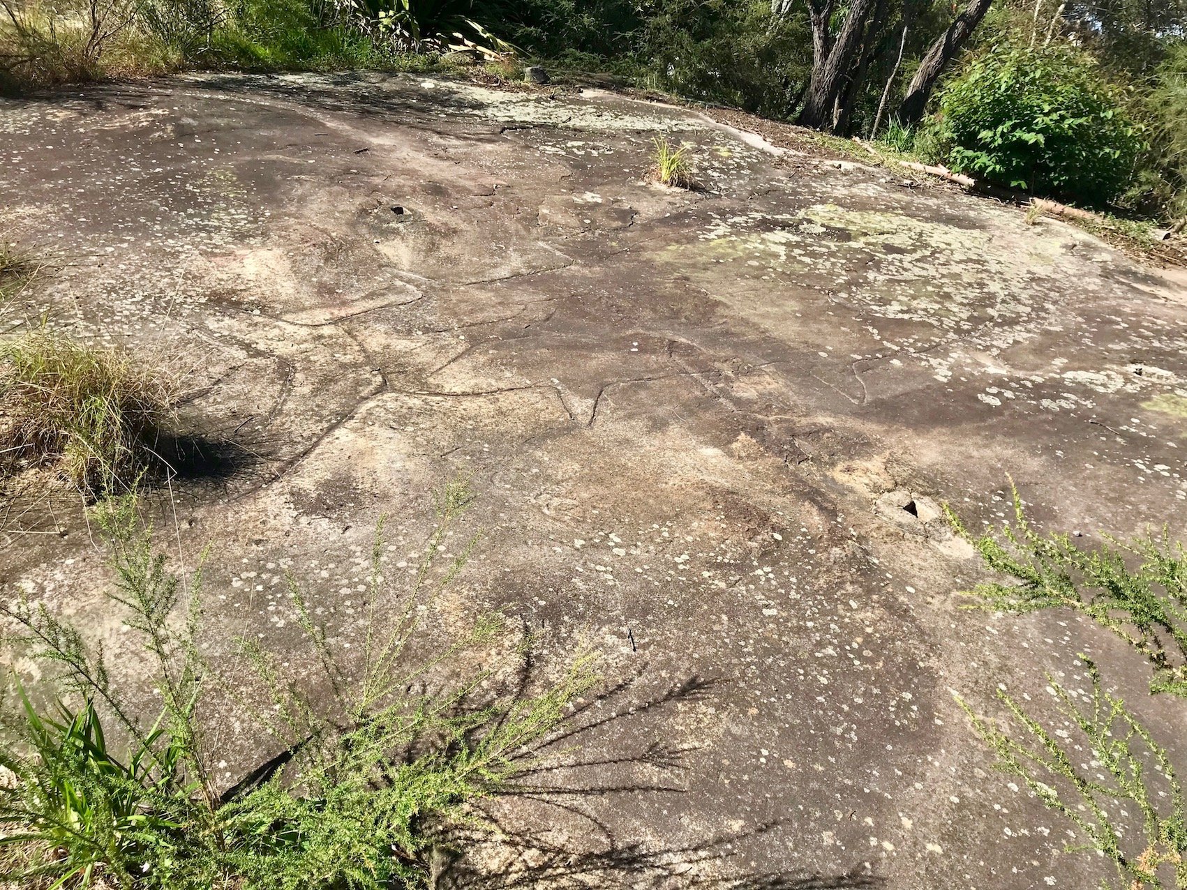
Aboriginal heritage sites, engravings & middens (Balls Head & Berry Island)
Tom’s Cabin rock shelter dwelling
Harbour bush tracks & lookouts over Berrys Bay and Parramatta River
Berry Island Gadyan Track loop & tidal beach access
Waverton Peninsula industrial-heritage parkland
-
Limited parking in streets around Coal Loader
Easy rail access: start Waverton, finish Wollstonecraft (or return)
Multiple stairs between Balls Head and Berry Island
Some bush tracks uneven or rocky — wear good walking shoes
Berry Island beach accessible mainly at low tide
Toilets at Coal Loader and Berry Island Reserve
Limited shade on exposed sections near Balls Head point
Allow extra time to explore Coal Loader and Waverton Peninsula Reserve
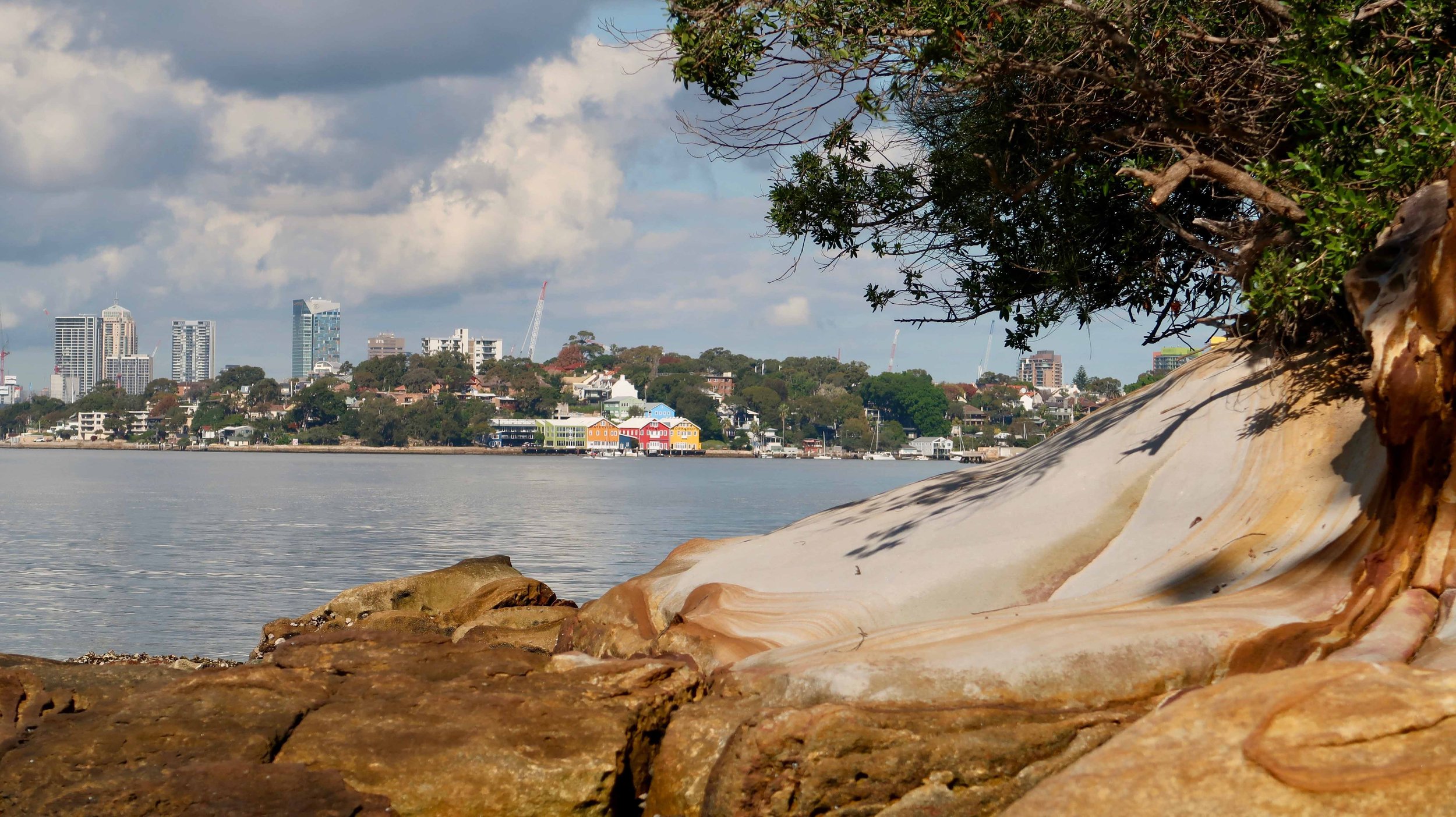
Like most harbourside walks, the views you get on this one are amazing. Unlike many though, this one feels like a real bushwalk.
There are two options for this walk: The short (ish) one, or the long one. The first is concentrated in Balls Head, taking in the Caol Loader and the nearby park. The longer walk continues on to Berry Island. Both are outlined here.

BALLS HEAD & BERRY ISLAND WALK
Distance 6.5 km Steps 9000 +
Time 2-3 hours Level of Difficulty Easy/Moderate
Getting there
The walk begins and ends at Waverton Station. Waverton has a refined village feel. It is quiet and the area has largely managed to avoid the overcrowding high rise of its near neighbours.
Leaving the station, turn left on Bay Road and walk down, passing a few village shops and cafes along the way.
Bay Rd becomes Balls Head Road and at this point on your right, you’ll have expansive views of the Parramatta River. Heading down the hill you’'ll see a big carpark behind a high fence. This is the naval base for HMAS Waterhen. Named after the RAN destroyer which sank off Tobruk in 1941, the base was used by the US and Australian navies in World War II. It is now the base for a number of mine hunters and support vessels.
A little further down Balls Head Road you’ll be directed right toward to the Coal Loader via WaterhenDrive.
A place of history
Entering the coal loader site you’ll pass an Aboriginal Bush Foods Garden and a large engraving of a whale with some faint figures inside. The engraving was first recorded in the late 1890s and is evidence of Aboriginal occupation in the area long after colonisation. The Aboriginal name for Balls Head is Yerroulbine and it was home to the Cammeraygal People.

Turn right and you’ll find yourself among the buildings of the old Coal Loader which now houses the Genia McCaffery Centre for Sustainability.*
Turn left when you come to the old mess hall and walk between the buildings until you see the café and toilets. We’ll come back to this area later. For now, turn right and take the stairs down towards the water then turn left.
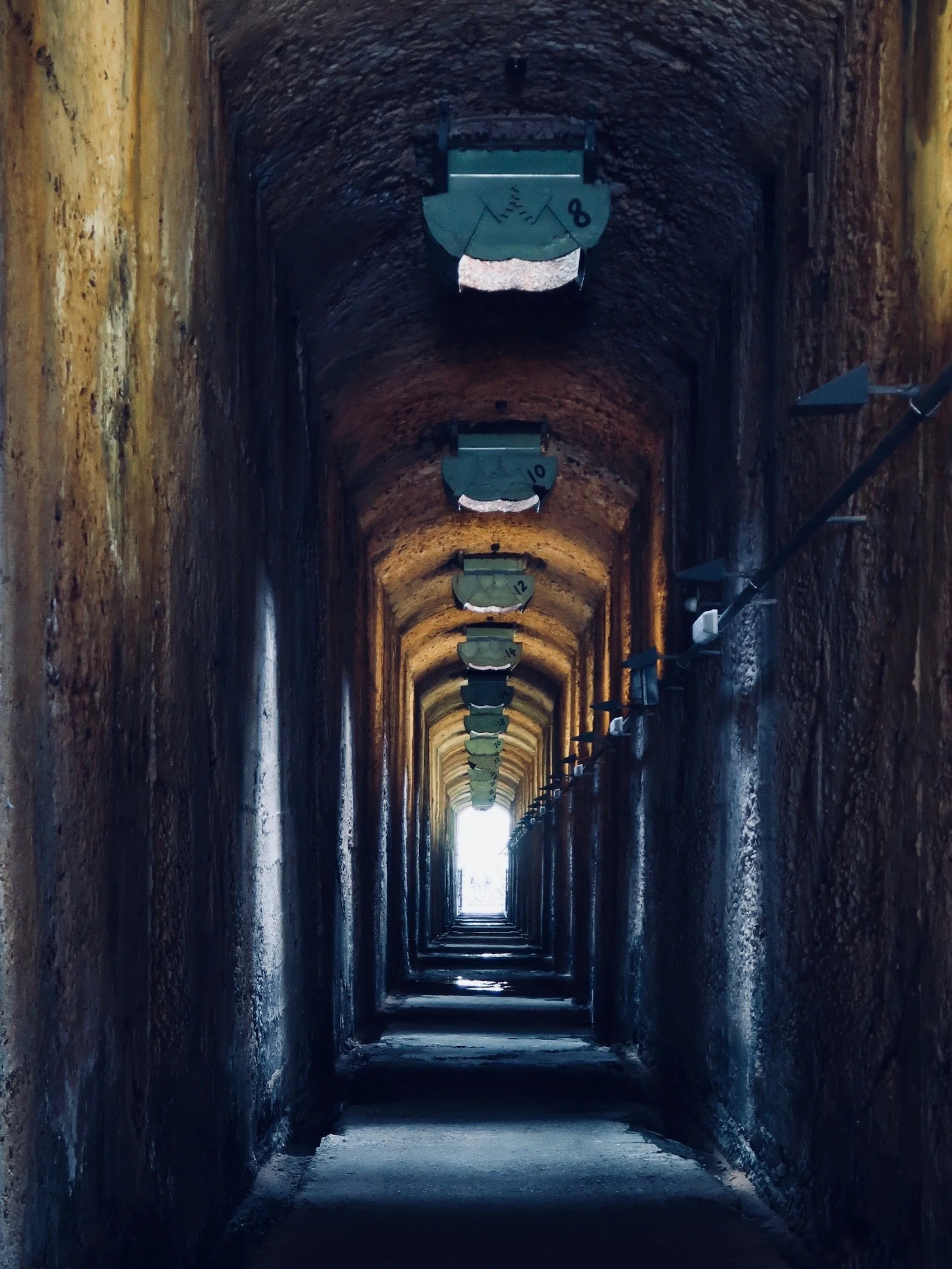
Walk along the path beside the bay and you’ll soon see a rickety old timber-decked wharf, a remnant of the coal loader, and a rusty old lighthouse tender called MV Cape Don which is being restored with plans to turn it into a museum. At about this point you’ll come to a huge sandstone wall. Built into this wall are arched entrances to the four tunnels that once serviced the coal loader platform above. Only one of these tunnels is open for access and it will take you through to the start of the bush walk proper on the other side. The tunnel is dark, damp and just a little bit spooky, but the promise of light and open air is soon realised and you’ll find yourself on a pretty bush track.


A series of trails
The walk around Balls Point offers many diversions and it can get a bit confusing. I followed the Coal Loader Link Track, which meets up with the Isabella Brierley Track. This leads to the Harbour View walk or the Ballisters Track, both of which take you around to the point to the start of the Midden Track. It doesn’t really matter which track or trail you take for it’s hard to get lost. Use the harbour to orient you for it’s never far from view.
Rooms with a view
For thousand of years, the Cammeraygal People lived in this area, fishing in the harbour and sheltering in and under the sandstone rocks and overhangs. It is thought that Balls Head Reserve was a site where men came to perform sacred ceremonies to honour their Dreamtime ancestors. Engravings, deposits and middens found in the area suggest that Aboriginal people continued to live here until as late as the early twentieth century.


When the Great Depression hit the larger population in the 1930s, groups of homeless people began to form shanty towns around the harbour. They made dwellings out of old stone store houses and natural caves built into the rocks.
One of the last remnants of these dwellings is Tom’s Cabin and you can see it by taking the lower path just off the the Harbour View Walk. You’ll see a natural rock shelter converted into a cabin with concrete, timber and a heavy metal door used to shore up its open front. The cabin, which also included a fireplace and chimney, is thought to have been occupied throughout the thirties and forties before being taken over by North Sydney Council worker Tom Stacey who inscribed the words ‘Toms’ Cabin’ into the lintel above the door.
The Harbour View Walk and Ballasters Tracks will both take you around to the point. There are plenty of places to stop for a picnic and the uppermost track will will take you to toilet facilities and barbecues. The view to the harbour from here are great though Blues Point Tower does its best to block out the bridge.
The Midden Walk
As you turn the corner you will start what is known as the Midden Walk, named for the shell middens known to be in the area. There are no signs pointing to these middens and though I looked, I was unable to find them. No matter; less disturbed, better preserved.
The midden walk looks over Berrys Bay and over to McMahons Point. At low tide there is a pretty little beach which you can get to via a path beside the old Quarantine Depot. The depot was established in 1912 to service boats operating to and from the Quarantine station at North Head. It is now used by the Maritime Museum for restoration work.


The Coal Loader
Remember the spooky tunnel you walked through earlier? Walking up the hill from the Qauarntine Depot you’’ll soon find yourself on the Coal Loader platform which sits on top of that tunnel. The Coal Loader operated from the the early 1920s until it was decommissioned in 1992. It functioned primarily as a transfer depot where coal was moved from bulk carriers to smaller vessels and trucks for redistribution.
How different it looks today! The platform, once covered in a large stockpile of coal, is now home to one of Sydney’s largest publicly accessible green roof spaces. The platform and adjacent buildings serve as a model of sustainability where visitors can learn not only about growing plants but also how to incorporate sustainable design into their own projects through energy and water-saving technology, stormwater harvesting, solar technology and recycling.
Also on the site is a community garden and bushland nursery as well as public meeting rooms, art studio spaces and toilets. There’s a cafe here too, From Sylvia, which specialises in all things gluten-free. A great place to stop for breakfast, lunch or a coffee before continuing in to Berry Island.


Exit the coal loader and head up past HMAS Waterhen.
If you’ve had enough, continue up the hill to return to Waverton Station or take a left into Horace Street to continue the walk
To Berry Island
Leave the Coal Loader the way you entered, making your way back along Waterhen Drive, back on to Balls Head Road and then take a left on to Horace Street.
At the end of the street take the steep stairs down to Sugar Works Reserve. Turn right and follow the path along Oyster Bay. The huge residential development that faces the water is Wondakiah estate and it sits on the site of the old gas works which operated here from 1913 to 1987. Can you smell gas? I think I could.
Take the stairs up to Badangi Reserve. If you have time, have a wonder around this pretty reserve before following the sign to Berry Island via Shirley Rd at the end of which you’ll find Berry Island Reserve.
The Gadyan Track
Berry Island is not actually an island, though it was in times gone by. It is now connected to the mainland by this grassy reserve with its picnic tables and barbecue facilities.
The Gadyan Track is a fairly short circular walk that loops its way around the island. Signage along the way points out significant historical sights in the area which was long home to the Cammeraygal people. The word Gaydan is their word for the Sydney cockle, a shellfish common in the area. The remnant middens on the island point to its popularity.
The walk along the Gaydan Track affords great views, especially at the point, and though the oil tanks around Greenwich aren’t exactly pretty, they are a reminder that Sydney still has a very active working harbour. At low tide you can pretty much skirt around the whole island at water level and once you’ve explored the bush track above, I recommend scrambling down to the sandy beach if the tide allows.


As you head back to the picnic reserve you’ll pass what I think is one of the prettiest waterside playgrounds in Sydney, (if you can ignore the ugly silos across the water). The play equipment is made mostly of timber and the swings, slippery dips, and climbing frames blend beautifully into their natural bushland surrounds. Its a nice spot to sit, with or without kids, and on a weekday it is pretty quiet.
You’re nearly done now. Wollstonecraft Station is straight up the hill on Shirley Rd or take the pathway to your right just before Tryon Rd to get back to to the gas works and rejoin the path on which you came.
If you’ve still got some energy as you head back along Horace St, cross Balls Balls Head Rd and take Woolcott St down to Waverton Peninsula Reserve and the old BP industrial site.
The old BP site
The dramatic topography of this park is due to both its history as an industrial site and its subsequent remediation. The former BP site once housed more than 30 huge oil tanks on concrete blocks carved out of the sandstone cliffs. When the site was set aside as parkland, decontamination works meant further excavation and cleverly deigned raised walkways now look down over cavernous spaces interlaced with native landscaping which does much to pull it all together.
Take some time to stroll up, down and around the old BP site. On site signage will give you a better sense of the history of the area.


To end the walk, make your way back to Ball’s Head Rd and up to Waverton Station.
Look out for signage directing you to download the Coal Loader App. The app, developed by North Sydney Council invites visitors to scan QR codes to explore three different trails including History, Native Animals and Sustainability. It uses advanced technology to provide an exciting interactive experience by creating digital encounters with animated animals, historical re-enactments and bringing sustainability concepts to life.